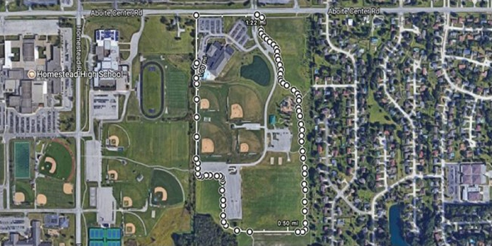
Here we can see, “How to Measure Distances in Google Maps for Running, Biking, and Hiking”
When using Google Maps to get directions, you can quickly see how far away the location is. However, here’s how to use Google Maps to find the distance between point A and point B on a hiking or running track.
This method works on a computer’s web interface, as well as on iPhone and Android. However, it does not work in a mobile browser’s web interface. So, without further ado, let’s get started. In my situation, I’ll be measuring the length of a large trail loop around the local YMCA.
On a Computer
- To begin, open any online browser on your computer, go to maps.google.com, and zoom in on the location you want to visit.
- Click the “Measure Distance” option after right-clicking the starting point of the distance you wish to measure. This is done in the Satellite layer, but you may perform it in any layer you wish.
- Follow the trail and click wherever it curves to place measuring marks that exactly follow the trail’s path.
- During the process, you can zoom in and out as much as you want to be as precise or as rough as you like.
- The distance travelled thus far is displayed at the bottom of the “Measure Distance” popup during the marking procedure.
- It also displays the entire square footage of the region, which is useful if you’re building a whole circuit or want to see how big something is.
- If you accidentally add a point, click it again to remove it. To modify the course, you can add points anywhere along the line and drag them around.
- Complete the circuit by clicking on your starting point again if you’re creating a circuit rather than a basic point A to point B measurement. Your starting point will not be changed as a result of this.
On iPhone and Android
- Open Google Maps and search for the spot you wish to measure.
- Tap and hold the beginning point where you wish to start measuring the distance. At that point, a dropped pin shows.
- Then, at the bottom of the screen, tap the white “Dropped Pin” box.
- Select “Measure Distance” from the drop-down menu.
- At this point, a second point appears. It may land where you’re currently standing rather than where you want it to go. Zoom out and drag the screen around to position the second point exactly where you want it. This may appear perplexing at first, but if you try it out for yourself, you’ll immediately understand.
- Tap “Add Point” in the bottom-right corner of the screen when you have a second point where you want it.
- Continue dragging the screen to the desired location for the next point, then press “Add Point” once more. Rep to this process until your path is completely marked.
- You can undo the last point you made at any moment by using the Undo button at the top.
- You can also press the ellipses button and then “Clear” to restart from the beginning.
- You’ll get a real-time update on the overall distance you’ve indicated as you go. Unfortunately, unlike the desktop browser interface, the app does not display the entire area.
It’s not ideal, and the web interface on a computer is far more convenient for noting distance than the mobile app, but it should give you a reasonable idea of the path’s length.
Conclusion
I hope you found this information helpful. Please fill out the form below if you have any queries or comments.
User Questions:
- How do I use Google Maps to track my bicycle distance?
Search for the location or route you wish to look at in the Google Maps app. Near the upper right corner of the screen, click the Map Type symbol. Under “Map Details,” choose “Cycling.”
- Can I calculate distance using my phone?
According to Ars Technica, Google’s augmented reality app “Measure” turns ARCore-compatible Android handsets into digital measuring tapes. The programme appears to be straightforward to use. Simply open Measure, point the phone’s camera at an object and select two places from which to measure the distance between them.
- Is it possible for Google Maps to track my walking distance?
Google Maps allows you to effortlessly record distances between two or more locations, as well as build routes for your jogging workouts. Using Google Maps, these apps allow runners and walkers to easily calculate the distances of their runs, walks, jogs, and treks.
- On my Pixel 3, Google Fit has poor accuracy while monitoring bike rides.
Google Fit low accuracy when tracking bike rides on my Pixel 3 from GooglePixel
- App to track the distance travelled in my walks/runs with GPS but without the need for an account
App to track the distance traveled in my walks/runs with GPS but without the need for an account from androidapps


